IIT Bombay FOSSEE GIS
Activities for the Calendar year 2024
The IIT Bombay FOSSEE GIS team announces the schedule (tentative) for its flagship activities for the calendar year 2024.
About the IIT Bombay FOSSEE GIS project & partners:
The IIT Bombay FOSSEE GIS team promotes the usage of GIS-based Free/Libre Open Source Software and Open Source Hardware in academia and industry. It also promotes the use of various indigenous Indian technologies like NavIC (ISRO), etc. The FOSSEE-GIS team is part of the FOSSEE project, developed at IIT Bombay which is funded through the National Mission on Education through ICT (NMEICT), Ministry of Education, Government of India. The Rural Data Research and Analysis (RuDRA), Lab, IIT Bombay (India’s first HPC-powered data center dedicated to Rural Development, housed in the Centre for Technology Alternatives for Rural Areas (C-TARA), Indian Institute of Technology Bombay) is the ‘Technical Partner’. The IIT Tirupati Navavishkar I-Hub Foundation - IIT Tirupati’s Technology Innovation Hub (TIH), funded by the National Mission on Interdisciplinary Cyber-Physical System (NM-ICPS), Department of Science and Technology (DST), Government of India is the ‘Organising Partner’ for select flagship activities.
Hindustan Times article featuring IIT Bombay FOSSEE GIS activities: https://www.hindustantimes.com/cities/mumbai-news/how-amateur-mapmakers-are-solving-real-world-problems-101696138619348.html
The IIT Bombay FOSSEE GIS mandates:
- Indian Citizens Only
- Use only Free/ Libre Open Source Software and Open Source Hardware
- Align with any SDG (UNDP). Use indigenous Indian technologies like NavIC (ISRO), etc wherever possible.
- The study area should be India-specific (mandatory).
- Work on real-life data sets (mandatory).
- Adhere to the (Indian) National Geospatial Policy 2022 (mandatory).
- Use Indian Satellite data (recommended).
- Use shape files only from the Survey of India portal (mandatory).
- Problem statements to be Inclined towards Gati Shakti (recommended).
- The participant(s) must be a bonafide student/ faculty/ staff of the institution recognized by UGC/ AICTE/ AIU or a body recognized by the Indian/ State Government.
The IIT Bombay FOSSEE GIS project activities include but are not limited to…
- Creating awareness about various GIS-based Open Source software/ hardware tools in Educational Institutions, Research and Innovation councils/ forums across India through thematic workshops, faculty development programs, panel discussions, support in the inclusion of Skill based GIS-centric course(s) in the curriculum (Academic Council/ Board of Studies) as per NEP 2020; partnerships; advisory, etc in the foundational level.
- Conducting national level (general and domain-specific competitions)… (a). IIT Bombay FOSSEE GIS Mapathon (Edition I (2020); Edition II (2022); Edition 3 (2023))- considered to be the world’s biggest open-source-based geospatial mapping challenge; (b). GIS-based IoT Hackathon; (c). Maritime Geospatial Hackathon; (d). Geospatial Agriculture Hackathon, etc.
- Conducting the (a). IIT Bombay FOSSEE GIS Summer Fellowship and Internship; (b). FOSSEE-GIS Semester Long Internship.
- The DST-Chanakya-FOSSEE National Geospatial Fellowship.
- National-level GIS Case Studies (General and Domain Specific).
- Internship-based GIS product development (i.e.) GIS on Cloud; GIS in Birding; GIS in History, GIS in Wildlife, etc.
- Open Source GIS Day (September 15, 2023).
- IUMAP certification program on GIS & RS.
- (viii). Annual FOSSEE-GIS Institutional partner subscription program (with exclusive members-only benefits).
- (viii). Pan-India Academia-Industry connect.
- (ix). Job Fair for FOSSEE-GIS alumni and annual FOSSEE-GIS Institutional partners.
- (x). GIS Summer/ Winter School.
- (x). National level Annual FOSSEE-GIS awards (for FOSSEE-GIS alumni and annual FOSSEE-GIS Institutional and industry partners).
- and more…
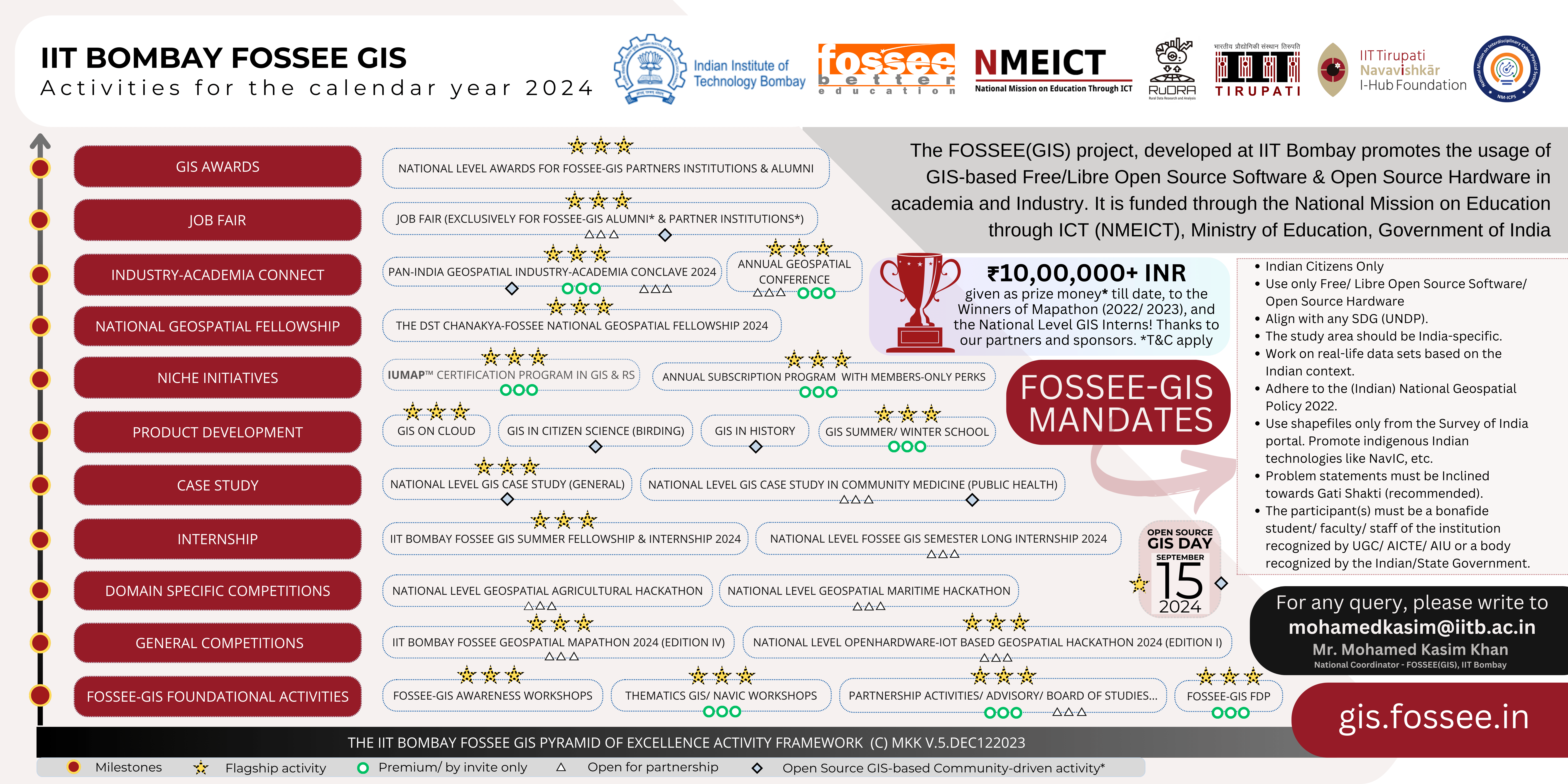
The IIT Bombay FOSSEE GIS Pyramid of Excellence activity Framework v.5.dec122023 (C) MKK
The detailed schedule (tentative) of activities is put here.
National Level OpenHardware-IoT based Geospatial Hackathon (Edition 1) 2024
The “National Level OpenHardware-IoT based Geospatial Hackathon 2024 (Edition 1)” is more than just a competition; it's a platform for innovators, creators, and visionaries to come together and pioneer solutions for a brighter future. Our purpose is to harness the power of open-source hardware, the Internet of Things (IoT), and Geographic Information Systems (GIS) to address some of the world's most pressing challenges. The FOSSEE project, IIT Bombay promotes the use of Free/ Libre Open Source Software in academia and Industry. The FOSSEE project is funded through the National Mission on Education through ICT (NMEICT), Ministry of Education, Government of India. The FOSSEE-GIS team manages the overall coordination of the "IIT Bombay FOSSEE GIS Internship in Geospatial Dashboard Design and Implementation". For more details, please visit https://iot-gis-hackathon.fossee.in/
|
Registration Open |
November 15, 2023 |
|
Registration Ends |
December 31, 2023 |
|
Inauguration |
January 01, 2024 |
|
Week 1: Kickoff and Orientation |
January 01 to 07, 2024 |
|
Week 2: Deep Dive into IoT and GIS |
January 08 to 14, 2024 |
|
Week 3: Prototyping and Development |
January 15 to 21, 2024 |
|
Week 4: Final Touches and Presentations |
January 22 to February 04, 2024 |
|
Presentations by Hackathon Teams |
February 05 to February 10, 2024 |
|
Results Declaration |
Feb 12, 2024* (Tentative) |
URL: https://iot-gis-hackathon.fossee.in/
National Level NavIC (ISRO) Workshop
|
NavIC workshop date |
January 29, 2024 (Tenative) |
URL: /* will be updated soon*/
IIT Bombay FOSSEE Geospatial Mapathon 2024 (Edition IV)
Mapathon is a map making competition for creating thematic maps, using open source data and mapping software. It is a collaborative event where participants come together to develop new tools/methods that improve the accuracy and usefulness of maps for a community. The FOSSEE team at IIT Bombay, along with its partners the Rural Data Research and Analysis (RuDRA) Lab, IIT Bombay and IIT Tirupati Navavishkar I-Hub Foundation (NM-ICPS, DST, Government of India) (earlier partners were AICTE, ISRO) will invite all Indians - to produce maps using various data (e.g. observation data, remote sensing data, crowdsourced data, etc.). The primary objective is to understand the potential of remote sensing data and make maps for Indian regions using free open source mapping software (e.g.: QGIS). The participants will collectively work in a crowd sourcing method for jointly producing thematic maps of India. The data collected from various platforms have tremendous potential in mapping India’s resources, agriculture, climate and disaster management, rural and urban planning, and identifying pathways for future development. Such maps can be created using Free open Source platforms (such as QGIS). Let us join together to create such maps through the Mapathon. Mapathon also aims to develop indigenous capacity to customize and employ mapping to resolve societal challenges and create new opportunities for young India.-. The primary objective is to understand the potential of open source mapping and maps for Indian regions and to build capacity for the same.
|
Registration Open |
Feb 15, 2024 |
|
Registration Ends |
Mar 25, 2024 |
|
Inauguration |
Mar 20, 2024 |
|
FAQ session |
Apr 01, 2024 |
|
Submission Window starts |
Apr 01, 2024 |
|
Doubt clearing session 01 |
TBD |
|
Doubt clearing session 02 |
TBD |
|
Submission Window ends |
May 10, 2024 |
|
Evaluation Window |
May 13, 2024 to May 27, 2024 |
|
Results Declaration |
June 15, 2024* (tenative) |
URL: /* will be updated soon*/
For any queries, please write to mohamedkasim@iitb.ac.in
National GIS Case Study (General)
Applications are invited from the Deans/ Directors/ Principals/ HODs of reputed (top 100 NIRF Institutions) in India offering Hydrology, Disaster Management, Soil conservation, Wildlife, Geography, Geology, Geoinformatics, Remote Sensing, Rural Development, Urban Studies, Policy, and GIS-based Engineering courses.
Selected teams/ institutions will win a chance to work closely with the IIT Bombay Faculty and the experts from the IIT Bombay-FOSSEE-GIS team. Best proposals will also get to participate as co-authors in impactful research work carried out in the GIS domain by the IIT Bombay-FOSSEE-GIS team.
|
National GIS Case Study start date |
January 15, 2024, onwards |
URL: /* will be updated soon*/
GIS Case Study in Community Medicine (Public Health)
The application window is now open for established MEDICAL COLLEGES & RESEARCH CENTRES in INDIA that have a strong Community Medicine Department with/without Data Center facility. For more details, write to mohamedkasim@iitb.ac.in
|
GIS Case Study in Community Medicine start date |
January 30, 2024 onwards |
GIS Case Study in localization of SDGs in Panchayati Raj Institutions
The GIS Case Study in localization of SDGs in the Panchayati Raj Institutions will be based on the RDO framework developed at the Rural Data Research and Analysis (RuDRA) Lab, IIT Bombay. The application window for this activity will open in the first week of January 2024. For more details, write to mohamedkasim@iitb.ac.in
|
GIS Case Study in Community Medicine start date |
January 30, 2024 onwards |
IUMAP™ certification program
International Union of Mappers for Atlas and Planning is a trademarked initiative of the Rural Data Research and Analysis (RuDRA) Lab, IIT Bombay. The certification program which will be jointly conducted by IIT Bombay-FOSSEE-GIS and the RuDRA Lab will be mainly focused on GIS and Remote Sensing using Open Source Software. The process of the IUMAP™ certification program is being finalized. Detailed information will be made available of www.rudra.iitb.ac.in and https://gis.fossee.in.
|
IUMAP™ program start date |
March 15, 2024 (tentative) |
URL: /* will be updated soon*/
GIS on Cloud
The “GIS on Cloud” is an Open Source Software based community-driven product development activity initiated by the IIT Bombay FOSSEE-GIS team. This will be a unique opportunity for students having Remote Sensing. GIS, Geology, Geography, Geoinformatics, Environmental Science, Hydrology, Civil Engineering, Architecture, Urban planning, Rural Development, Policy, and Computer science with Open Source Software coding background to participate in this activity of national importance as an Intern, under the mentorship of eminent faculty from IIT Bombay, the FOSSEE(GIS) team, and partner institutions. For more details, please write to mohamedkasim@iitb.ac.in.
|
GIS on Coud start date |
March 25, 2024 (tentative) |
URL: /* will be updated soon*/
National Level Agro-GIS Hackathon 2024 (Edition 1)
A dedicated Geospatial Hackathon using Free/Libre Open Source Software and Open Source Hardware in Agriculture.
|
Registration Open |
Mar 15, 2024 |
|
Registration Ends |
Mar 31, 2024 |
|
Inauguration |
Mar 20, 2024 |
|
FAQ session |
Apr 01, 2024 |
|
Submission Window starts |
Apr 15, 2024 |
|
Doubt clearing session 01 |
TBD |
|
Doubt clearing session 02 |
TBD |
|
Submission Window ends |
May 10, 2024 |
|
Evaluation Window |
May 13, 2024 to May 27, 2024 |
|
Results Declaration |
June 15, 2024* (tenative) |
URL: /* will be updated soon*/
National Level Maritime-GIS Hackathon 2024 (Edition 1)
A dedicated Geospatial Hackathon using Free/Libre Open Source Software and Open Source Hardware in Maritime field.
|
Registration Open |
Jun 15, 2024 |
|
Registration Ends |
Jun 30, 2024 |
|
Inauguration |
Jul 01, 2024 |
|
FAQ session |
July 08, 2024 |
|
Submission Window starts |
July 15, 2024 |
|
Doubt clearing session 01 |
TBD |
|
Doubt clearing session 02 |
TBD |
|
Submission Window ends |
Jul 31, 2024 |
|
Evaluation Window |
Aug 05, 2024 to Aug 10, 2024 |
|
Results Declaration |
Aug 13, 2024 (tentative) |
URL: /* will be updated soon*/
National Level FOSSEE-GIS Semester Long Internship
The IIT Bombay FOSSEE GIS team invites applications for the National Level Semester-long Internship 2024 for students (Indian citizens) currently studying in Colleges across India. The selected students will get an opportunity to work with the FOSSEE(GIS) team for one semester (subject to performance review every month). This is a remote internship with continuous support and mentoring. To get shortlisted for the internship, the applicant/ student will be asked to select from a list of projects and choose a screening task during the time of application. Then the student needs to complete at least one of the screening tasks. The selection will be purely based on the evaluation criteria of each screening task. The FOSSEE (Free/Libre and Open Source Software for Education) project promotes the use of FLOSS tools in academia and research. The decision of the evaluation team will be final at all circumstances. The FOSSEE project, IIT Bombay is funded through the National Mission on Education through ICT (NMEICT), Ministry of Education, Government of India.
|
Announcement of the Internship |
January 01, 2024 |
|
Last date for registration |
January 10, 2024 |
|
Submission of screen task (end-date) |
January 23, 2024 |
|
Result announcement |
January 30, 2024 |
|
Internship begins on |
February 01, 2024 |
URL: /* will be updated soon*/
IIT Bombay FOSSEE GIS Summer Fellowship and Internship 2024 (Edition II)
The IIT Bombay FOSSEE GIS Sumemr Fellowship and Inetrnship 2024 is a flagship activity of the FOSSEE-GIS team, which will be conducted in two stages i.e. Stage 1: Summer Fellowship (First month); Stage 2: Maim Internship (02 to 06 months). Candidates will be chosen based on three categories.. (i). Winners of the IIT Bombay FOSSEE Geospatial Mapathon 2024 (Edition IV); (ii). Open Registration; and (iii). Special Purpose Vehicle (a special drive to get on board bright students from the North-Eartern States, J&K, Andaman and Nicobar Islands, etc). Candidates will be selected based on the strength of their S.o.P. (Statement of Purpose), and a screening task which will determine their ability to work using GIS-baed Free/Libre Open Source Software/ tools.
The IIT Bombay FOSSEE GIS Summer Fellowship and Internship is considered to be one of India’s most coveted internship’s in the Geospatial domain with over 3000+ unique applications received from students studying in various Universities/ Colleges across India. More details will be published on gis.fossee.in website.
Note:
- District Collectors/ Administrations, and Government Ministries can send us their problem statement which will be assigned to the interns, who will try to solve the problems under the mentorship of the IIT Bombay-FOSSEE-GIS team and from partner institutions.
- Interns get a monthly honorarium. This is subject to the recommendation of the evaluation committee.
- Students who have already been offered or have participated in any form of Summer Fellowship/ Internship conducted by the IIT Bombay FOSSEE GIs team will not be eligible to apply.
|
Registration Open |
June 15, 2024 (tentative) |
|
Registration Ends |
June 30, 2024 (tentative) |
|
Declaration of Results (based on S.o.P.) |
July 15, 2024 (tentative) |
|
Oritenation |
July 16, 2024 (tentative) |
|
Stage 01 - Summer Fellowship (start date) |
July 16, 2024 (tentative) |
|
Stage 01 - Summer Fellowship - 01-minute presentation by Interns |
August 16, 2024 (tentative) |
|
Stage 01 results |
August 20, 2024 (tentative) |
|
Stage 02 - Main Internship (start date) |
August 20, 2024 (tentative) |
For any queries, please write to mohamedkasim@iitb.ac.in
National level Geospatial Summer School
The IIT Bombay FOSSEE GIS team along with its partners plans to conduct a dedicated GIS Summer School as a premium offering for the students currently studying in Colleges across India. More details will be published before the registration start date on gis.fossee.in. Limited seats! The FOSSEE-GIS subscribed Colleges will have early bird access to the registration portal.
|
Registration |
May 01 to May 25, 2024 |
|
Release of list of selected candidates |
May 31, 2024 |
|
Summer School |
June 20 to June 30 |
URL: /* will be updated soon*/
The DST-Chanakya-FOSSEE National Geospatial Fellowship 2024
The DST-Chanakya-FOSSEE National Geospatial Fellowship is a joint initiative by the IIT Bombay FOSSEE GIS project which is funded through the National Mission on Education through ICT, Ministry of Education, Government of India, and IIT Tirupati’s Technology Innovation Hub (TIH) - the IIT Tirupati Navavishkar I-Hub Foundation (IITTNiF) which is part of the National Mission on Inter-Disciplinary Cyber-Physical Systems (NM-ICPS), Department of Science and Technology (DST), Government of India. Participation requires one to be a full-time bonafide student in any degree program at undergraduate, postgraduate, and Ph.D. level. Detailed information will be made available on request.
The DST-Chanakya-FOSSEE National Geospatial Fellowship is one of the few available coveted national-level fellowships in the Geospatial domain. Candidates for this flagship initiative are selected from the IIT Bombay FOSSEE GIS Summer Fellowship and Intnership 2023 (only the top 10 our of the 50).
|
DST-Chanakya-FOSSEE National Geospatial Fellowship 2024 - start date |
January 01, 2024 |
URL: /* will be updated soon*/
National Level Geospatial Academia-Industry Conclave
The National Level Geospatial Academia-Industry Conclave is planned to be conducted in September 2024. This will be an Open Source GIS community-driven activity with the subscribed partner Institutions of the FOSSEE-GIS project playing a vital role in the organizational part. Government agencies, Policy Makers, Companies/ Industries, professionals, etc in the GIS sector will be invited. The conclave will feature keynote sessions, panel discussions, parallel presentation sessions, and more.
Entitles willing to partner with us on this conclave can write to us <mohamedkasim@iitb.ac.in> for more information.
|
Date |
September 15, 16, 2024 (Tentative) |
URL: /* will be updated soon*/
Open Source GIS Day 2024
The Open Source GIS Day is an annual event celebrating Open Source-Geographic information Systems (GIS) based technologies.
|
Open Source GIS Day 2024 |
September 15, 2024 (Confirmed) |
URL: /* will be updated soon*/
Annual FOSSEE Geospatial conference
A national-level conference organized by the FOSSEE-GIS team in association with its partners and Industries in the Geospatial field. The Annual FOSSEE Geospatial Conference will be conducted at IIT Bombay.
|
Conference Date |
June 21 to 23, 2024 (Tentative) |
URL: /* will be updated soon*/
FOSSEE GIS Job Fair
A dedicated Job Fair in Geospatial domain for the alumni (Mapathon, Hackathon... Champions, Winners & Interns) of the FOSSEE-GIS project and for the student of FOSSEE-GIS subscribed Institutions. Companies looking for potential candidates for the GIS-based vacancies can write to us for participating in this job fair as a recruiter. For more information, please write to mohamedkasim@iitb.ac.in
|
GIS Job Fair date |
TBD |
National FOSSEE Geospatial Awards
National level awarding ceremony in the geospatial domain organized by the FOSSEE-GIS project in association with its partner institutions.
|
Date |
September 15, 2024 (Tentative) |
URL: /* will be updated soon*/
The FOSSEE-GIS team is part of the FOSSEE project, developed at IIT Bombay which is funded through the National Mission on Education through ICT (NMEICT), Ministry of Education, Government of India. The FOSSEE project is headed by Prof. Kannan Moudgalya (Principal Investigator.), Prof. Pennan Chinnasamy (Co.P.I.) leads the GIS vertical of the project, Mr. Mohamed Kasim Khan (National Coordinator - FOSSEE(GIS) & Sr. Research Scientist) coordinates the overall planning and implementation of the IIT Bombay-FOSSEE-GIS activities covering all the states and union territories of India.
Government agencies, Skill Development bodies, and Educational institutions (UGC/ AICTE/ AIU recognized Universities, Colleges, etc) seeking collaboration can write to <mohamedkasim@iitb.ac.in> us and help us spread awareness on the IIT Bombay FOSSEE GIS team’s national level initiatives for the benefit of their students, scholars, faculty, staff, and industry professionals.
Email: mohamedkasim@iitb.ac.in; gis@fossee.in
Phone: (022) 2567 4111
Venue: IIT Bombay (hybrid mode)
