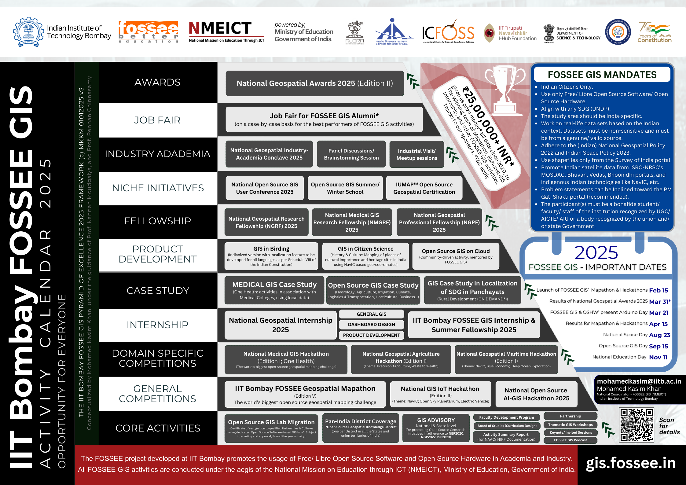
Geospatial FOSSEE Mandates
To participate in any of the Geospatial FOSSEE activities, the participating individual/team(s)/Institutions must follow the mandates as listed below:
- Indian Citizens Only.
- The participant(s) must be a bona fide students/faculty/staff of the institution recognized by UGC/AICTE/AIU or a body recognized by the Union and/or State Government.
- Use only Free/Libre Open Source Software/Open Source Hardware.
- Activity must align with at least one SDG (UNDP).
- The study area should be India-specific.
- Work on real-life data sets based on the Indian context.
- Datasets must be “non-sensitive” and from a “genuine/valid source”.
- Adhere to the (Indian) National Geospatial Policy 2022 and Indian Space Policy 2023.
- Use shapefiles from the Survey of India Portal ONLY.
- Use Indian satellite data from ISRO-NRSC’s MOSDAC, Bhuvan, Vedas, Bhoonidhi portals, and indigenous Indian technologies like NavIC, etc.
- Problem statements can be inclined toward the PM Gati Shakti Portal (recommended).
- The qualified entries of all IIT Bombay FOSSEE GIS (NMEICT) initiatives shall be released under the Creative Commons (CC-BY-SA or related) license.
Services
FOSSEE GIS Activities

Geospatial Mapathon
Join us in the world's biggest open-source-based geospatial mapping challenge.

National Geospatial Internship
A unique opportunity for students studying in a university/College in India to showcase their geospatial skills to the world by solving India-specific real-world problems that require thematic maps as solutions, in accordance with the National Geospatial Policy 2022 and the Indian Space Policy 2023

Medical GIS (HPHF Industry Connect)
Connecting the Open Source Geospatial domain with the world of Medicine through our industry partner HPHF

FDPs & Workshops
Participate in the dedicated Workshops and Faculty Development Programs Co/Organized by us and/or our partner institutions.
Since 2019+
Serving India, covering all States and Union Territories up to the District level
Open Source Geospatial/GIS Capacity Building
The biggest coverage.
350+ Districts, 2000+ Educational Institutions & counting...
Dedicated to promoting Indian satellite Data and indigenous Indian tech. including NavIC (ISRO)
All FOSSEE GIS activities are conducted in adherence to
National Education Policy 2020
National Geospatial Policy 2022
Indian Space Policy 2023
Working on real-life problem statements based on the Indian context
1000+ Interns
Happy learners and counting...
150,000+
Our Features
FOSSEE GIS & partner organizations specialize in
Summer/Winter GIS Schools
Provide a world-class Open Source-based GIS/Geospatial training twice a year. Keep checking the upcoming activities section for more details.
Curriculum Design
After the advent of the National Geospatial Policy 2022 and the Indian Space Policy 2023, the FOSSEE GIS and the RuDRA lab team support deserving institutions with designing the best Open Source-based GIS/Geospatial curriculum.
Open Source GIS Lab Migration
Need help in migrating your Remote Sensing/GIS lab to Open Source? Please write to us!
Advisory
To build Geospatial capacity at the national level, we forge advisories with various government agencies and educational institutions for better outreach and to extend of program benefits to the student community and faculty.
Upcoming FOSSEE GIS events and activities...
| Date | Event Name | Partner Institute Name | Venue | Faculty Coordinator | State/UT | Category | Remarks |
| 15 to 19 June 2026 | GIS and Data Analysis using Open Source AI | Honeybee Population Healthcare Foundation | Parul University | Dr. Viduthalai Virumbi & HPHF team | Gujarat | FDP | Special session on FOSSEE GIS by Prof. Pennan Chinnasamy & Mohamed Kasim Khan M |
| 07* July 2026 | State-level Open Source GIS Orientation Session for SPPU Affiliated Colleges (Maharashtra) | Savitribai Phule Pune University | | Dr. Amit G. Dhorde (Open Source Geospatial State Coordinator - Maharashtra) & Dr. Ravindra Medhe (Open Source Faculty Coordinator for SPPU) | Maharashtra | FDP + Workshop | For 700+ Colleges affiliated to SPPU |
| 27 & 28 August, 2026 | National Conference of Urban Environment and Disaster Management: Urban Sustainability, Resilience and Risk Reduction | Regional Centre for Urban and Environmental Studies (RCUES-Osmania University) - Ministry of Housing and Urban Affairs, Government of India | Osmania University | Dr. Srinagesh, Director, RCUES-OU (MoHUA, GoI) | Telangana | National Level Conference | |
| TDB* | National level GIS Summer School | TBC | | * | TBD | Summer School | TBA |